About Topography - Earthworks
Complete topographic leveling tool for both field work in road construction. Road-building tool: complete set of tools for leveling in route, comprising: - Manager mile markers: from a txt file format, which previously we...
Complete topographic leveling tool for both field work in road construction.
Road-building tool: complete set of tools for leveling in route, comprising:
- Manager mile markers: from a txt file format, which previously we added a list of mile markers, we can get the height of flush kilometer we need, even if present in a section with vertical agreement . And besides, at the time of calculating the level, will also calculate the left and right camber (in the sense of lower kilometer to kilometer higher), which correspond to the kilometer calculated. Obviously, these data are stored, and we use them in reframing tab order to work with them.
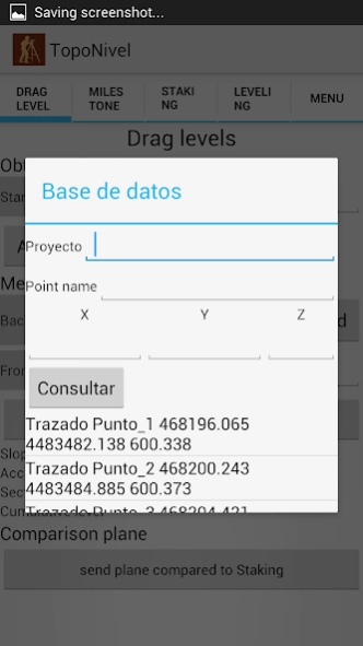
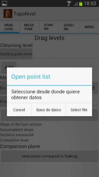
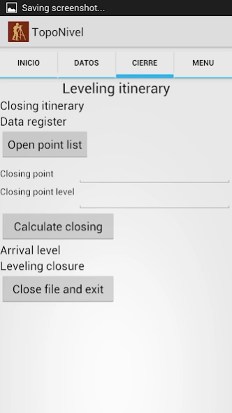
- Drag and closing levels: using leveled to reach the work area. In the case of drag, to reach the area, calculate our comparison plane and send it to the stakeout tab. To close, we will have all the necessary functions to start the journey back, and get to our starting point, calculating the closure of leveling.
- Staking: starting from our grade level, camber, and comparison plane obtained in the tabs above, we can calculate quickly and easily the elevation of any point we need in our road layout. It cant be changed at any time, and update the data when necessary.
Leveling routes registration and precise leveling
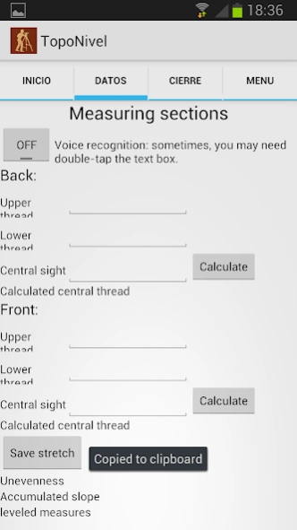
- Normal Leveling: leveled reading log middle, and intermediate points function to register (name and its corresponding point elevation) that are of interest to our work.
- Precise leveling: read the three threads, and comparison of the central wire read, with the central wire calculated by the program.
- All the level and intermediate points collected will be stored in a txt file, to work with him later in cabinet.
Points leveling tool: ideal for civil works. From a known height, we can get a comparison plane, and calculate leveling staking any point we need, without having to calculators, or accessories of any kind.
Previous Versions
Here you can find the changelog of Topography - Earthworks since it was posted on our website on 2013-08-22 04:50:15.
The latest version is 2.0.0 and it was updated on 2024-04-22 13:55:11. See below the changes in each version.
Topography - Earthworks version 2.0.0
Updated At: 2017-09-10
Changes: Functions and design update.
Actualizaciones en funciones y diseño.
Topography - Earthworks version 1.9.0
Updated At: 2014-01-10
Changes: Thorough review of design and functionality.,Now the application is more dynamic and agile voice recognition is optimized.,Updated and ready to work with my Database application
Topography - Earthworks version 1.7
Updated At: 2013-06-23
Changes: Several fixes and updates
Disclaimer
Official Google Play Link
We do not host Topography - Earthworks on our servers. We did not scan it for viruses, adware, spyware or other type of malware. This app is hosted by Google and passed their terms and conditions to be listed there. We recommend caution when installing it.
The Google Play link for Topography - Earthworks is provided to you by apps112.com without any warranties, representations or guarantees of any kind, so access it at your own risk.
If you have questions regarding this particular app contact the publisher directly. For questions about the functionalities of apps112.com contact us.